
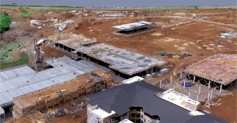
Virtual design and construction teams are quickly discovering the value that drone mapping brings to all stages of a construction project, including initial site survey and design, volume and elevation measurements and comparisons, and quality assurance. In a fraction of the time it takes to conduct a ground-based survey, a drone can automatically fly and capture imagery of a project site that can then be processed into highly-accurate point clouds compatible with Building Information Modeling (BIM) software.
The VDC team at Brasfield & Gorrie, one of the largest privately-held construction firms in the United States, is setting the standard for the use of drone mapping in construction. Brasfield & Gorrie has equipped each of their regional offices with DJI Inspire series drones and their 24-person VDC team has incorporated drone mapping into their everyday business practices.
Survey-Grade Models Produced in a Fraction of the Time
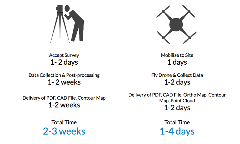
Using traditional ground methods, a 60-acre site could easily take two or even three weeks to survey. For Brasfield & Gorrie’s VDC team, drone mapping reduces that process to four days or less from initial request to importing the point cloud to BIM software. Some of the biggest time savings come from the data collection step. For most construction sites, it takes less than an hour to fly and capture mapping imagery. Then, just upload the flight photos to the cloud-based DroneDeploy platform and wait for them to be processed into a map and 3D model — without taxing your own servers.
And project managers don’t need to sacrifice accuracy either. By using ground control points (GCPs), DroneDeploy customers can achieve centimeter-level accuracy. Once the 3D model is complete, DroneDeploy allows VDC teams to export point clouds into local coordinate systems by simply entering a 4-digit EPSG code. The result: survey-grade data in a fraction of the time compared to traditional ground survey methods.
“We saw what was a 2–3 week and several tens of thousands of dollars process become a 1–4 day process with only a couple thousands of dollars invested in equipment and software,” says Cole. “When you’re looking at a dramatic 75% or greater cost and time improvement — it’s really powerful.”
High-Resolution 3D Models Revolutionize the Work of VDC Teams
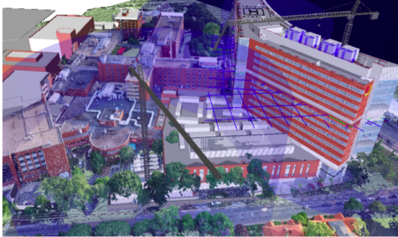
Not only are drone-based surveys faster to perform than ground-based surveys, but they also deliver much more detailed data. A traditional survey may only yield a few hundred points of resolution, whereas drone-generated point clouds can contain millions of points. The result is a high-resolution 3D model that is revolutionizing the work of VDC teams and the project and site managers they work with. Cole noticed the extent of this when he analyzed a 3D model of one of Brasfield & Gorrie’s sites.
The 3D point cloud was so detailed that he could see each powerline over the site and each individual stud in the multifamily apartment complex under construction. In fact, the point clouds his team produces are so detailed, that when he showed one to a colleague recently, it was mistaken for a video.
“I said no, no, this is actually a 3D point cloud, and I can get the volume of any material stockpile on that site, I can make any linear measurement — so this is a really detailed point cloud that showcases the quality of data you can get.” — Hunter Cole